If you find yourself headed to Las Vegas, either for a conference, music festival or because of a cheap flight deal, then you might be surprised to learn that it’s a great destination for outdoor enthusiasts. Sure, the flash and sparkle of The Strip gets all the credit, but there is more to Las Vegas than casinos and cheap booze. In fact, there are some great places for hikes in the vicinity of the city. So, if you find yourself in Sin City and craving a good hike, below are some of the best hikes for you to check out.
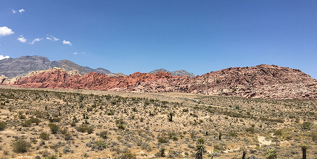
Red Rock Canyon National Conservation Area
Located about a half hour west of The Strip, Red Rock is a local favorite for day hikes, mountain biking, and rock climbing. More than 20 trails are easily accessible direct from the 13-miles scenic loop that goes through the park. If you’re traveling with kids, or just want an easy hike, choose either the Red Spring boardwalk or Lost Creek Children’s Discovery trail. But if you only have time one for trail, and can handle easy to moderate terrain, then go on the Calico Tanks trail. You’ll get to experience the best of the scenery that Red Rock has to offer, and when you reach the highest vantage point you’ll be rewarded with an amazing view of the Las Vegas Strip.
Valley of Fire State Park
Located about an hour’s drive northeast east of the city, this 35,000-acre park is the oldest in the state. And it offers up some amazing scenery. With more than 10 official trails to choose from, the Rainbow Vista trail is one of the most popular due to the array of colors that hikers get to see on the rocks. This trail is easy to moderate, with only some slight inclines. For an easier trail, check out Mouse’s Tank trail where you can view some ancient petroglyphs on the canyon walls. Just be warned that this trail floor is entirely desert sand that will get in your shoes.

Mount Charleston
Located about a half hour northwest of the city, Mount Charleston is part of the Spring Mountain Range and Toiyabe National Forest and a welcome cool retreat for visitors and local during the hot summer months. There are over 50 marked trails to choose from, which range in difficulty. But the best part about these trails is that Mount Charleston is often less crowded than the other popular hiking spots. The Mary Jane Falls trails is the best option for those who want an easy hike, plus you get to see a waterfall on this trail. If you prefer to take in canyon walls, then go on the equally as easy Fletcher Canyon trail. For those a bit more seasoned, the best half-day hike options are the Cathedral Rock trail for it’s amazing views and the Big Falls trails for its 100-foot waterfall.

Though these three parks offer some of the best hikes in Las Vegas, you can also find great options just a few hours outside of the city. So, if you have the time, consider a day trip to Death Valley or Zion National Park in Utah.